
Practical Urbanism: Insights from Car Free America's Mark Brown
Navigating Budgets, Politics, and Public Opinion When Creating Human-Scale Places

Dave Deek: Your work clearly demonstrates your deep expertise in urban planning. Could you share your professional journey? What experiences led you to focus on car-free and car-light urban design, and what inspired you to write Human Speed and Car-Free America?
Mark R. Brown, AICP: Becoming car-free in 2011 really inspired me to take multimodal planning seriously. I didn't really understand transit, bicycle, or pedestrian infrastructure at the ground level until then. I was like many planning and engineering professionals, having learned basic concepts in graduate school, but not learning how to apply them or what really made a place accessible to people without cars. Trying to navigate American cities without a car really opened my eyes. I saw how many traffic models were inaccurate and overestimated traffic. This led to overbuilding surface streets that didn't need so many automobile lanes. I also began to see the need for mode separation, both in time and in space.
Here's an example: Left and right turning vehicles crossing into crosswalks while pedestrians have a "Walk" signal. This seems pretty innocuous as a driver, but becomes a dangerous problem when you're a frequent pedestrian. Giving pedestrians more dedicated time that they're protected from turning traffic (from a no-turn-on-red sign and Leading Pedestrian Intervals) would go a long way in improving pedestrian safety. Something like this didn't occur to me until I became a pedestrian myself.
I started my career at Baltimore DOT. That's where I gave up my car because the city is so rowhome-y and walkable. I began focusing on multimodal projects from there. I then worked at Dallas DOT for 5 years where I helped design major bike lane and road diet projects, then I came here to Florida where I continue my work at Miami Dade County managing their Vision Zero Program and other ped/bike initiatives.
What led me to write Human Speed was I was hoping other people could relate to the journey and maybe be inspired by it. A lot of people may have a secret wish to live a different kind of lifestyle, not burdened by excessive transportation expenses and the frustrations of traffic. I understand for some, this might not be possible due to family obligations, job locations, etc. I also admit in the book the lifestyle is mostly selfish and not for a greater cause, though there are environmental benefits. I did it to save money and get in shape. What I didn't realize was how it would change my perspective on transportation planning.
Barcelona's Urban Planning Model
Dave Deek: In your article about Barcelona's transformation, you highlighted their Superblocks model and protected bike network. Which elements of Barcelona's approach do you think are most applicable to American cities, and what adaptations would be necessary given our different infrastructural and cultural contexts?
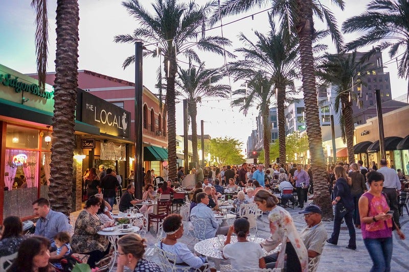
Mark R. Brown, AICP: I think pedestrian-only streets are definitely applicable to U.S. cities, similar to what Barcelona had designed. Not at that scale, however. Finding 3 or 4 solid, healthy blocks in a downtown area with no curb cuts, auto access or delivery access needed is key. Low hanging fruit. Giralda Ave. in Coral Gables, FL is an excellent example of what we can do in the U.S. That street is the most lively row of restaurants in the entire city. And now it's completely pedestrianized.
Pedestianizing streets had a bad reputation in the U.S. up until recently. When I lived in Baltimore, there were several blocks near downtown that were closed to car traffic in the early 1970s in hopes of revitalizing the neighborhood (Old Town Mall). The plan backfired and more businesses moved out, but that had to do with broader neighborhood decline and not necessarily the car free blocks. But you can find a lot of examples from the 1970s and 1980s where cities tried to build pedestrian spaces that didn’t take off. I think we’ve learned a lot since then and how to build off of neighborhood strengths. The Superblock model isn’t a panacea. A lot of other factors have to be right in order for car free blocks to work.
The political will to build these spaces needs to be stronger in the U.S. to make it happen, however. A city needs a strong community advocate and also a strong political advocate working on the inside. That's a good start. But starting with a small pilot project is a great start for U.S. cities.
Bike Infrastructure Strategy
Dave Deek: You've advocated for building complete bike networks all at once rather than incrementally. What strategies would you recommend for cities with limited budgets that still want to achieve meaningful cycling infrastructure? Are there ways to prioritize certain connections that maximize impact?
Mark R. Brown, AICP: Many times, a city can build a solid, complete bike network in their downtown without having to relocate curbs or rebuild streets. This saves on construction expenses. Using movable curbs (either rubber or concrete) bolted into the asphalt combined with bollards can help separate the bike lanes from traffic lanes. You can see the new bike network in downtown Miami for an example.
Also, a city should determine places people actually want to go and pick the most direct paths to get there. A lot of times bike routes are circuitous and avoid major commercial/retail streets because of perceived traffic conflicts. In Barcelona, there were protected bike lanes on major commercial streets like Gran Via de les Corts Catalanes because this is where all roadway users (not just drivers) want to go. It's also been shown that cyclists, over the long term, spend more money than drivers at local stores. Yes, bike riders may not be able to carry as many things with them, but they tend to visit shops more frequently. Bike networks are good for the local economy. This point should be sold more often when planning bike infrastructure.
Building Public Support for Infrastructure Changes
Dave Deek: Despite the clear safety benefits of roundabouts that you mentioned in your guide to them and the fact that cities, especially more conservative cities, that have them like Carmel loves them a lot, there's still resistance to implementing them in many American communities. What approaches have you seen work best for building public support for these types of unfamiliar infrastructure changes?
Mark R. Brown, AICP: I've used case studies to show completed projects in other cities. If there's drone videos, that's even better. Before and after data as well to show its effectiveness. If a completed project is nearby, even a field trip to see it in person is great. The comparison project should be in a city that's somewhat similar to your own, though. Showing examples in NYC or LA is usually counterproductive unless you're in Chicago or Mexico City or something.
Transforming Streets: The Giralda Avenue Example
Dave Deek: The Giralda Avenue example in Coral Gables is interesting. What was the process like to transform that street? Were there significant objections from businesses or residents, and how were those concerns addressed to achieve the successful outcome you described?
Mark R. Brown, AICP: Giralda was a 2-lane street with parallel parking and struggling restaurants. The Business Improvement District and City Commission had the idea of pedestrianizing the space in 2014. Through a series of public meetings and visual presentations, they won the public over. Each component of the project was considered a piece of art, from the planters to the pavers to the color of the tiles. It was inspired by public spaces in Spain, with opportunities for temporary art installations as well.
After construction, there was also a rezoning that allowed residential uses and balconies to help make the space more lively. I wasn't involved in that planning process so I'm not sure what hurdles were overcome, but I imagine traffic considerations played a big role in the planning process. That's usually the major issue to overcome, including deliveries and emergency access (which is still maintained in the plaza). If you can get people comfortable with the deliveries, emergency access, and traffic impacts of the space, that’s like 80 percent of the battle right there.
Economic Arguments for Bike Infrastructure
Dave Deek: You mentioned that cyclists tend to spend more money at local stores over time. Have you found this economic argument to be effective when advocating for bike infrastructure? What data or metrics have been most persuasive when making the case to skeptical stakeholders like business owners or budget-conscious officials?
Mark R. Brown, AICP: If the bike route is on a commercial corridor, the economic argument can be effective. That's one of the main concerns of business owners: Will this bike lane hurt my business? You need to show that it won't. That bike lanes can actually help their businesses.
Other metrics I've found useful are bike lane cost per mile compared to roads/highways, before/after retail sales of similar bikeways, maintenance costs (usually minimal), ridership trends, safety data, and oh yes, impacts to traffic. A lot of people are concerned new bikeways will increase traffic congestion, especially if the project is part of a road diet. Traffic studies and data from comparable projects are useful. Dedicated, protected bike lanes are good for all modes and can reduce congestion and crashes, including for automobiles. Framing bike lanes as benefiting everyone, not just cyclists, is important. For every protected bike lane we build, we’re getting a lot of cyclists out of traffic (and off the sidewalks) and into their dedicated space. That reduces traffic conflicts and can reduce traffic delay since there are fewer cyclists holding up cars.
Shifting Transportation Department Culture
Dave Deek: In your article on traffic safety education, you mentioned the need to rethink how we teach engineering standards. Have you seen any transportation departments successfully shift their internal culture from prioritizing speed and delay metrics to prioritizing safety? What specific policy changes or leadership approaches made this transformation possible? Are similar strategies also needed to be applied to architecture training?
Mark R. Brown, AICP: I know NYC DOT shifted many of their auto-centric metrics to more holistic, safety-focused metrics (speed, injuries/fatalities, etc). Like many other cities, they also lowered their speed limits and de-emphasized level-of-service. Washington State DOT also did the same and is focusing on safety metrics. WSDOT integrated safety into employee performance goals, requiring engineers to justify designs based on crash reduction potential. Florida DOT is also making safety a priority, identifying major crash causes and proactively incorporating safety into many of their projects.
But it's a big problem. The U.S. has the highest roadway fatality rate per 100,000 people of any developed nation. It will really take every state and local DOT to change their focus, and that means civil engineering and transportation planning schools also need to change their focus away from automobile level-of-service and towards safety. That’s where the real change has to happen. My CE courses were filled with traffic models, LOS calculations, and getting traffic through links and nodes as fast as possible. A lot of curricula are still like that, but hopefully that changes.
Measuring Complete Street Project Success
Dave Deek: With the increasing rhetoric on data-driven decision-making in urban planning, what metrics or evaluation frameworks do you find most effective for measuring the success of complete street projects beyond just crash data? How do you recommend cities track and communicate the broader economic, social, and environmental benefits of these interventions?
Mark R. Brown, AICP: I think surveys and resident/business interviews are an underrated feedback mechanism. All metrics that can be collected have already been collected for complete streets projects, but hearing directly from the people who live and work in the community is the gold standard. Interviews and surveys encapsulate almost all of the metrics you mentioned in a qualitative, more nuanced format.
Also, Barcelona tracked air quality when they pedestrianized many of their streets. They also tracked public health outcomes like child asthma ER visits. They found that after construction, the pedestrianized blocks had lower ER visits and lower particulate matter levels. I don't see many U.S. cities doing that, but that's something that could be valuable and have a direct impact on people's lives.
Building Coalitions Among Advocacy Groups
Dave Deek: In your work promoting more livable, multimodal cities, you've likely observed the sometimes fragmented nature of urban advocacy. Groups like Strong Towns, YIMBYs, New Urbanists, and traditional bike and pedestrian advocates often share many goals but can differ significantly in their approaches, priorities, and messaging. Is this just an online thing? From your experience implementing successful projects on the ground, what strategies have you found most effective for building coalitions across these different advocacy communities? Can you point to a specific project where diverse stakeholders with differing urbanist perspectives collaborated effectively despite their theoretical differences? What lessons might this offer for communities trying to advance substantial transportation changes in politically complex environments?
Mark R. Brown, AICP: Many times, advocacy groups want the same thing, but they want it their way. I've seen bike advocacy groups actually kill bike projects because the proposed bike facility wasn't the type they preferred. So, it's an online thing and also a real-life thing. I think involving groups early and often and making everyone feel they're part of the planning process is important. Overlooking an advocacy group can create resentment and hurt a project down the road.
One project I'm really proud of that brought diverse advocacy groups together was the Henderson Ave Complete Streets project I worked on in Dallas. It was unique because we didn't come in with any preconceived notions about what the project would be. We knew we had about $1.5 million to spend and some vague priorities we received from City Commission, but the details were left open. In our first public meeting, we just presented the current conditions and some financial and engineering constraints and asked, "What do you want?" We collected the community's priorities and designed the project from that. Because everyone felt heard at those first few meetings, including advocacy groups, the project sailed through the planning and engineering process. Construction was completed in 2018. I think another small (and unexpected) thing that helped was how we physically set up the public meetings. It wasn’t an auditorium where we stood up in front of rows of people and talked at them. It was a workshop format which I think really helped disarm any us vs. them mentality. We had breakout groups with table moderators to help guide the discussions at each table. Whenever I see planning meetings in auditoriums, I cringe. It’s a small thing but it has a big impact.